To me, this setup has some shades of 4 May 2007 (Arnett/Greensburg) and 17 May 2019 (Forgan/Minneola) for the S Plains portion of each setup. But that doesn't mean it will have an outcome worthy of its own town names.
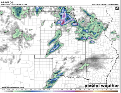
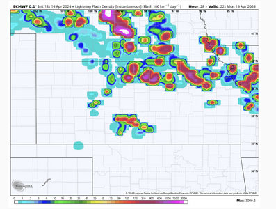
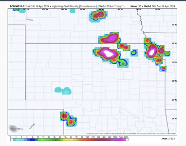
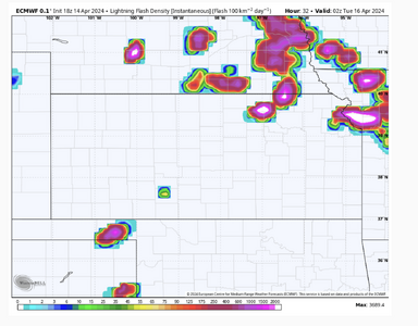
CAMs have not been very excited thus far about robust CI along the dryline, at least outside the deeply mixed air near I-20 in TX. However, there are some hints of CI in coarser guidance like the ECMWF, ICON, and even GFS... particularly during the 00z-03z timeframe.
Although the incoming wave timing is certainly later than "ideal," there are substantial mid-level height falls forecast even before 00z, with a strong upper jet punching into the OK Panhandle vicinity.
With all that being said: it's not like I'm sold on robust supercells before dark. It's 3-5 weeks earlier in the season than the two events I mentioned above, and moisture will be a bit inferior, as well. But if a subtle ripple in the upper flow, a dryline bulge, or whatever other factor manages to spark explosive convection during the early evening in the E Panhandles or SW KS, the tornado potential would obviously be considerable.
Ultimately, I think this is one of those textbook dryline gambles: even the best forecaster among us isn't going to know whether this is destined to be a cap bust; a significant, impactful event; or something in between until lunchtime or later. In my view, it's worth the gamble if you're within a few hours' drive of the W OK to C KS segment of the dryline, and it's one of those torturous high risk-high reward propositions if you're not.