Congrats to all who scored big on this day. Not sure it's even worth posting this report as I feel like the only chaser in western Iowa or eastern Nebraska on Friday, 4/26/24 who didn't capture spectacular tornado imagery. This was one of those days where it just wasn't meant to be for me. Unlike my worst busts of the past, there's not one major blunder I can point to that prevented me from scoring on the day. I didn't abandon a target that produced for one that didn't (6/16/14, 5/26/21); or lose total confidence in the day producing at all and go home, only for my target to produce anyway (4/9/15).
My target area produced tornadic storms (in fact, an almost absurd plethora of them, more than I would have dared hope for even had it been a high risk day!), and my target storm produced tornadoes...it just didn't do so while I had a good, close, unobstructed view under the base.
My leaving-the-house GPS target was Creston, IA (annoying since it turns out all I would have had to do was go there and wait for about 90-120 minutes!). Coming from Madison, WI and getting a little later start than planned, I was concerned that I wouldn't be able to make it to the far western IA/eastern NE target in time and I didn't like how close together the storms in that area were depicted on most CAM solutions (although of course it ended up not mattering on this particular day). Multiple runs of multiple CAMS (correctly, as it turned out) depicted storms crossing out of far northeast KS/far southeast NE, through far NW MO and into southwest IA, maturing into one to several robust supercells in a fairly potent tornadic environment in the 23-01Z timeframe. These were my target.
I spent most of the drive to the target along US-151, I-380 and I-80 in overcast and occasional showers. It wasn't until west of Des Moines that I finally began to break into peeks of sunshine, with my car thermometer starting to climb through the 60s, and clumps of very low clouds racing across the sky south to north (what I've come to learn is the classic "tornado sky" indicative of strong low-level shear).
I exited at Stuart and grabbed a late lunch at the Subway (it was now about 3:30 PM) while checking over data. The western portion of the target area had indeed fired early with numerous tornado-warned storms in close proximity from Nebraska City northward, and given the radar presentations and reports it was apparent I was missing
something, although I didn't yet know what. However, my target still looked good and those storms had in fact already fired over extreme SE NE/extreme NW KS, with a couple of them already sporting tornado warnings at least briefly. I decided I needed to jump on them ASAP, and instead of continuing to Creston as originally planned I rerouted to Red Oak intending to drop south from there for the intercept. This was probably my first mistake, although not yet fatal to my tornado chances for the day.
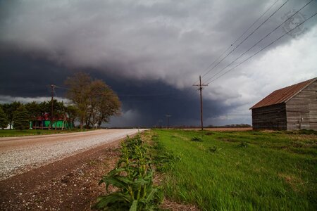
Dropping south from Red Oak, it became apparent I needed to give the storms a little wider berth before continuing into their paths, so I went east on IA-2 and then south again on US-71. My plan was to continue into far northwest MO, intercepting the second or third cell in the line (middle or tail-end Charlie). However, not long into this my phone blared a WEA for a tornado warning on the northernmost cell in the group, which I just happened to be right in front of! Radarscope showed a moderate couplet off to my southwest, so I turned west off of 71 between Shambaugh and Braddyville, IA to investigate.
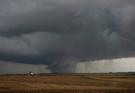
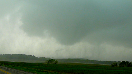
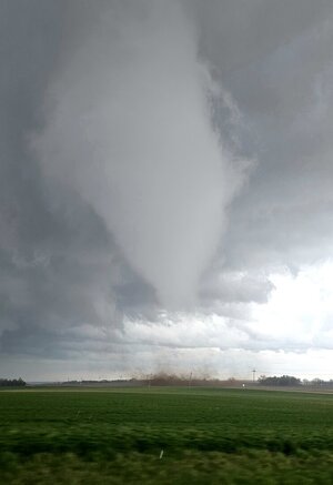
Clearing the hills and trees to the immediate west of 71, I was greeted with a very HP, rain-filled RFD region with an inflow tail extending to the north...definitely not what I was hoping to see. However, I pulled over to watch for a few minutes.
NOTE: All these images are frame grabs from either my dash-mounted GoPro or phone video...I took just one DSLR shot this entire chase (of the wall cloud southwest of Bedford) and never even got my 4K camcorder out of its case.

I realized that this rain-enveloped RFD region (which, based on visual and radar presentation, could contain a hidden tornado) was moving quickly and about to encroach on my position. I turned around and went east back to 71, then north. It was here that road options/road quality suddenly became a bit of a problem. I took the first east option available, 265th St. out of Shambaugh, which turned out to be a gravel road. My 2021 Hyundai Santa Fe is underpowered and despite being a 4WD SUV, slips and slides on this type of road almost as much as the front-wheel-drive compact cars I used to always chase in. The leading edge of the RFD gust front caught me with atomized rain curtains sweeping across the road, and blowing dust right at ground level that made it difficult to see the road, despite visibility being fine a few feet above. With a few minutes of white-knuckle driving, zig-zagging on these gravel back roads, I was able to break out of this and eventually found pavement again as this initial storm raced away to the northeast (it may have been the storm that later produced the tornado which impacted the far northwest edge of Creston, not sure).
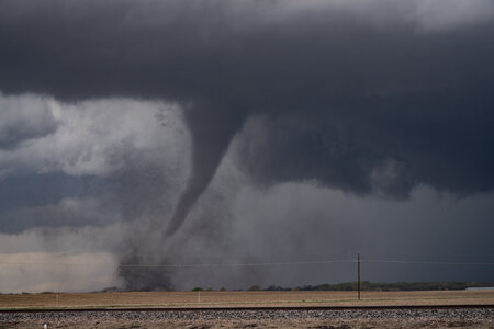
Emerging onto IA-148 south of Bedford, I turned right (south) to execute my original plan, dropping across the forward flank of the next cell in line to get a view of its updraft base. Again, moments into this my phone blared a WEA for a tornado warning on
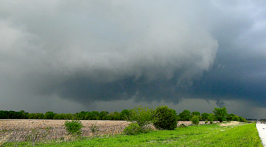
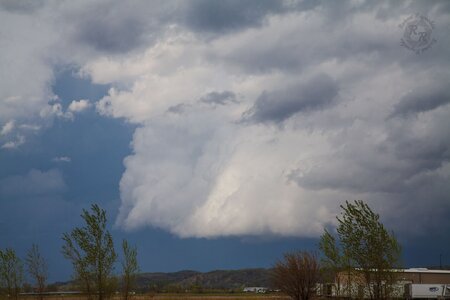
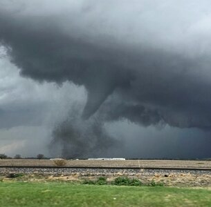
that cell. I thought I was in business. However, now I had a new problem. A solidly tree-covered ridge blocked my view to the west. I turned around and then turned left, west on the original road that I had come off of. Cresting a hill, a nice wall cloud came into view with clear slot and inflow tail evident.

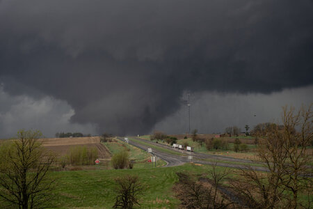
The wall cloud quickly moved across the road and behind the trees, so I turned around and went back to 148, then north. I pulled over to watch the wall cloud again for another minute or two. It briefly appeared to expand, with the tail cloud becoming quite prominent with intense rising motion, but I didn't observe strong rotation. Continuing through Bedford (where, rather disconcertingly, NO sirens were sounding despite being in an active tornado warning polygon with the wall cloud looming to the west) things got a bit hairy again as it became apparent the wall cloud and I were going to reach 148 and the intersection with my next east option at the same time. However, the wall cloud now appeared to be breaking up/gusting out (indicative of this particular cycle's failure at tornadogenesis, and the first hint of my chase being in trouble as I was now only just keeping even with this wall cloud, and the next cycle would be downstream to the northeast). Keeping my head on a swivel and peering straight up out the windshield (again noting strong rising motion but no strong rotation), I proceeded cautiously under the remnants of the wall cloud and took my east option.
Once again finding myself stair-stepping in a maze of sometimes paved, sometimes not rural roads as the storm suddenly started to look really good on radar, I had my first feelings of "oh crap, I've blown this." There was nothing for it but to press on, eventually I reached IA-25 and headed north from Clearfield. I was actually still within striking distance of the storm, but it was here I made what was likely my most significant mistake. I should have recognized that getting north, closer to the business end of the "horseshoe," was more important than getting east to stay ahead of the storm's longitude. With this in mind, continuing straight ahead to US 34 would probably have put me in great position to capture the series of tornadoes that would shortly ensue in the Creston-Afton-Macksburg area. However, I continued in "stair-step" mode and took County J13, Ringgold Union St. - another unpaved gravel road - east toward Shannon City.
I reached US 169 slightly east of the storm's longitude, but the base was now well off to the north. At this moment, a WEA blared over my phone for a new tornado warning on the next cell in line to the south. Noting that storm's radar presentation, I actually turned right (south) onto 169. However, my original storm just looked too good on radar and after just a minute or so I spun a uie and blasted north. The other storm ended up producing a tornado near Mt. Ayr which I may have been able to catch had I continued south (or I may have gotten into trouble trying to cross its path). Per chasers who caught it, this tornado displayed a dramatic multivortex structure and was likely stronger than its EF1 rating.
Anyway, my storm displayed dramatic supercell structure as I continued north toward it (admittedly taking some liberties with the speed limit on 169, which apparently still wasn't fast enough for at least one person, who passed me) with a lot of lightning in the vault region ahead of the updraft.
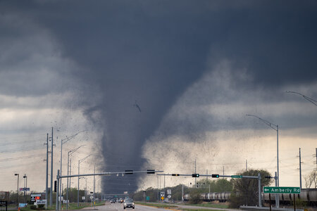
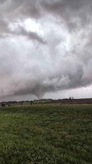
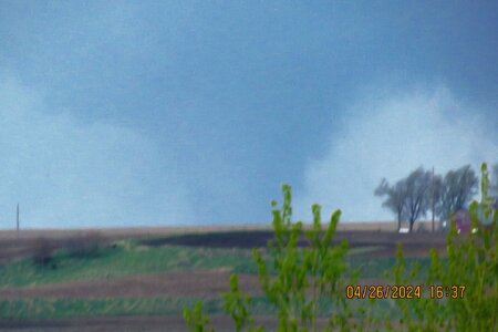
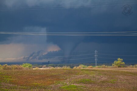
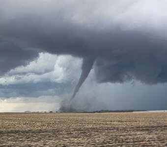
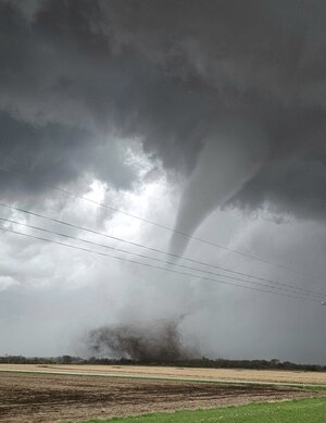
Descending a hill just south of Afton at 7:34 PM (per timestamp on the phone photos I took at the same time, which did not turn out through the raindrop-spattered windshield), I could finally see under the base in the distance and make out several "fingers" and lowerings. At least one of these is surely the EF2 which was occurring north of Afton at this time, but which?
This corresponds to the 10:27 mark in my video at the bottom of the post (zoomed in 450%, sped up 5X and contrast-enhanced).

Following 169 as it jogged east concurrently with US 34 before continuing north once again; I could get only tantalizing glimpses under the base to the west of the highway. Dramatic lightning in the vault region continued, including this curlicue bolt just as I was passing another car:

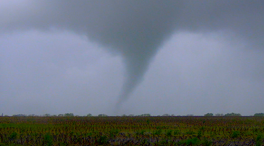
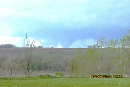
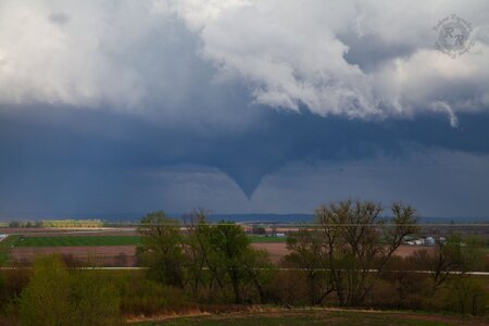
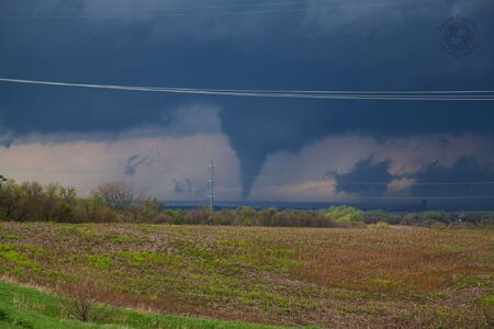
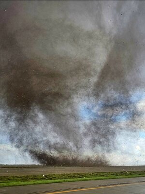
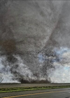
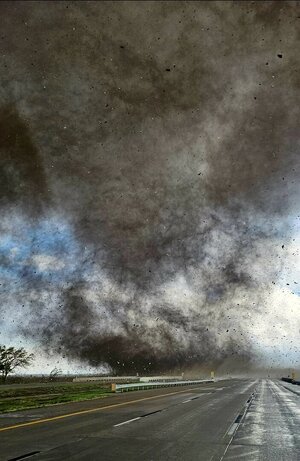
I decided to pull off to observe the storm a little ways south of Lorimor; per timestamp on my phone video this was about 7:48 PM, or two minutes after the aforementioned Afton-Macksburg-NW of Lorimor EF2 ended per DMX's survey. Making the turn off 169 onto (I think) 130th St., as lightning illuminated under the base there indeed did not appear to be a tornado in progress.

However, after I pulled over and started rolling phone video, squinting into the dusk-hour murk under the base (image is lightning-backlit and contrast-enhanced) I could make out what appeared to be a thin rope funnel cloud extending about halfway down. Of course, after I zoomed in on this feature the lightning did not flash behind it again until after it began to shrink/retreat seconds later.

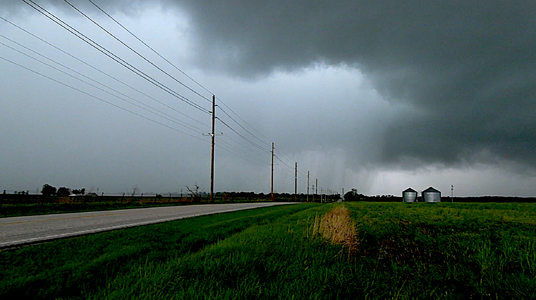
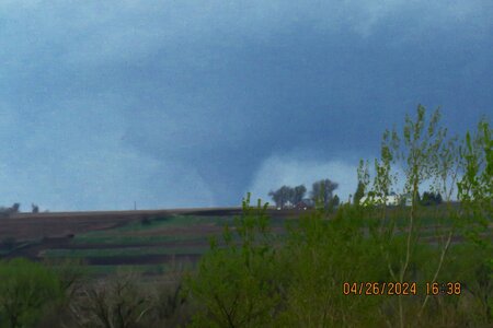
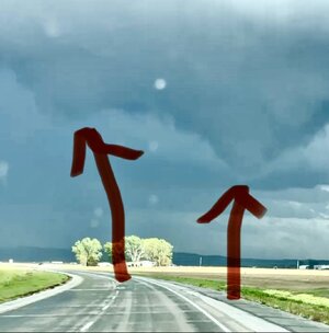
Continuing north on 169 past Lorimor, another wall cloud appeared to be taking shape in the distance to the north and once again it was a race to catch up to it. Meanwhile, another cell back to the southwest had gone tornado-warned with a prominent velocity couplet and was producing another EF2 from west to north of Afton, just west of the track of the first. With hills and trees blocking my view to the west from 169, I considered this couplet as something to stay clear of rather than try to see. Had I turned left instead of right at US 34 and just waited in Afton, I could have caught this one.
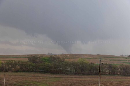
I turned right from 169 onto Peru Road at or just before 8:00 PM, as I did so lightning momentarily lit up this feature:

DMX's survey documents an EFU (unknown, no surveyable damage) tornado occurring from 7:57-7:58, east of 169 and just north of Peru Rd., so this was likely it or the remnant funnel just after it lifted. I followed this east on Peru Road for a few minutes, but observed no definitive ground contact even as frequent lightning backlit underneath.

With this storm getting away from me once again; at least two other tornado-warned couplets in the general vicinity, and darkness rapidly setting in I called the chase, returned to 169 and drove to a spot between Winterset and Lorimor where I was reasonably confident I'd be clear of the path of any tornadoes, pulled over and waited in blinding rain and strong (fortunately, not too crazy) wind for the RFD from the tornadic supercells to clear the highway.

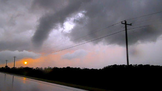
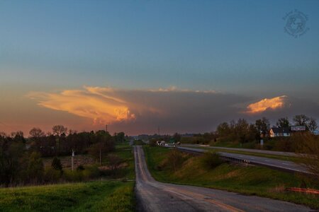
After the bulk of the weather had cleared the highway, I made my way to Winterset for gas and to collect myself for a little while before beginning the long drive home. As I did so, my GoPro caught more lightning:

I still wasn't completely in the clear, though as a tornado-warned supercell crossed my path on I-80 east of Des Moines well after 10 PM. This event continued far later into the night that I had been anticipating.


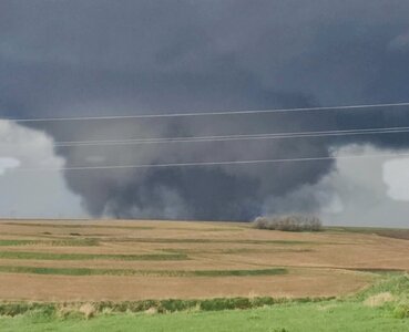


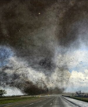
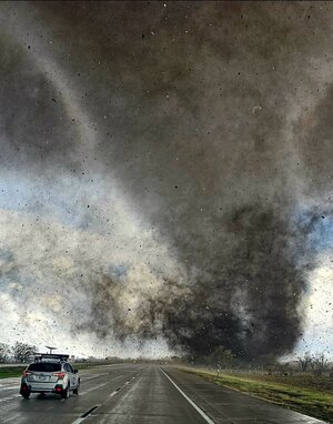
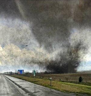
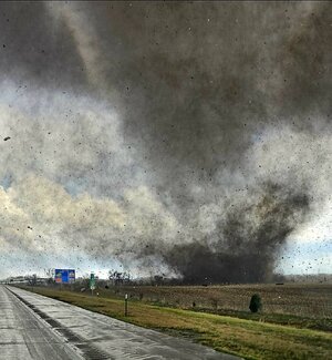
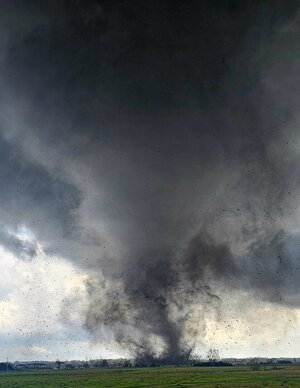
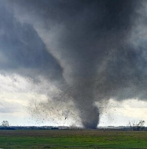
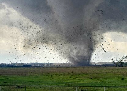


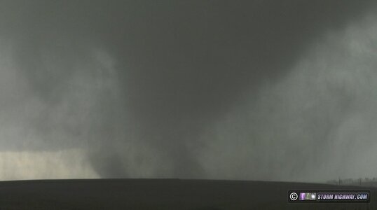
 We eventually ended up on IA-141 heading east toward Manilla where what appeared to be a satellite circulation developed in the field immediately to our south and crossed literal feet in front of the hood.