Blake Naftel
EF2
A complicated and muddy forecast analysis this morning with some atmospheric hints already to shape up. Will keep this brief. Currently in the Overland Park/KCI region with a FFZ [forecast focus zone] of north-central Oklahoma northeast to the Kansas border [Blackwell/I-35 towards Winfield] for mid/late afternoon, in favor for surface recovery and convective re-generation along a proposed outflow boundary hinted by several CAM’s. In real-time, the tornado warned supercellular convection, presently from Enid SW to Elk City, will be interesting to watch evolve; along with the mesoscale environment and attendant recovery as those storms populate northeastward into Kansas.
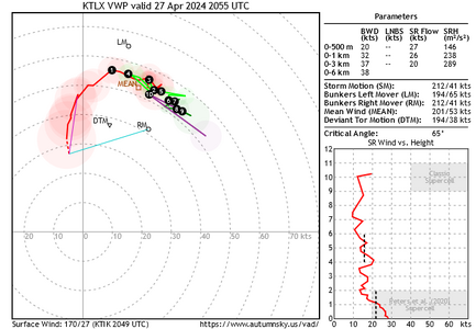
The 12Z OUN upper air sounding [actual, not simulated] is "loud and clear" in terms of potential tornado production for however the atmosphere evolves in NC/NE OKLA and SE Kansas today. Would be interested to see if a special sounding is released at ITC or TUL. Another region of potential interest is closer [to my present location] along Highway 75 from Osage City to Yates Center, KS for a rapid re-evolution with the present convection moving northeast for later today. All is rapidly materializing for a classic, frustrating high-end potential day either way. Shall see what transpires.
Will note for anyone chasing in Southeastern Kansas; numerous local and highway zones in specific areas [such as HW 59 north of Parsons and east of Chanute] were closed on Friday, likely due to flooding. Wise to keep a heads up on that aspect today! Good luck to all out and be safe. Busy day ahead!